The Pereiro Photovoltaic Power Plant (Phase 2) project, in Alcoutim, which is in the public consultation phase until the 7th of July, will have great «cumulative impacts», since within a radius of five kilometers there are already six other «licensed or licensing photovoltaic plants», as well as four power lines, two of them very high voltage.
The alert was launched by the ecologist platform Glocal Faro, which produced a proposal for an opinion, which can be copied or adapted by all those who wish to participate in the public consultation and oppose the project now under evaluation (see the draft below).
It is, in fact, the Environmental Impact Study itself that speaks of the «cumulative impacts» and lists similar projects planned or already existing in the municipality of Alcoutim, as well as in the neighboring parish of Cachopo, in the municipality of Tavira. However, the EIA concluded that the impacts will be minimal.
The Glocal Faro, on the other hand, also recalls that, in addition to all these investments planned in photovoltaic plants, "there is still the mining project throughout this municipality and in part of Castro Marim».
Even recently, in October of last year, the largest photovoltaic plant operating in Portugal was inaugurated, located between Vaqueiros and Martim Longo, also in the municipality of Alcoutim.
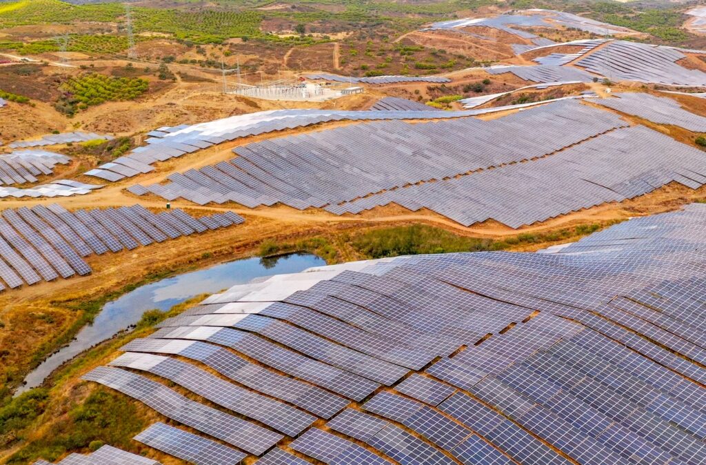
The Pereiro Project now in public consultation on the Participa.pt portal consists of the installation of a Photovoltaic Plant with 10,2 MWp of peak power to be installed, which takes advantage of solar energy, using traditional photovoltaic technology (photovoltaic panels) on a fixed structure. With this Project, an average annual energy production of 17,1 GWh/year is estimated.
The area destined for the Photovoltaic Power Station is located in the municipality of Alcoutim, in the Union of the parishes of Alcoutim and Pereiro. This Photovoltaic Plant, with a total of about 18 hectares, will be installed in an area adjacent to the Photovoltaic Plant of Pereiro (from Galp) which is currently under construction. This new plant is also promoted by Galp.
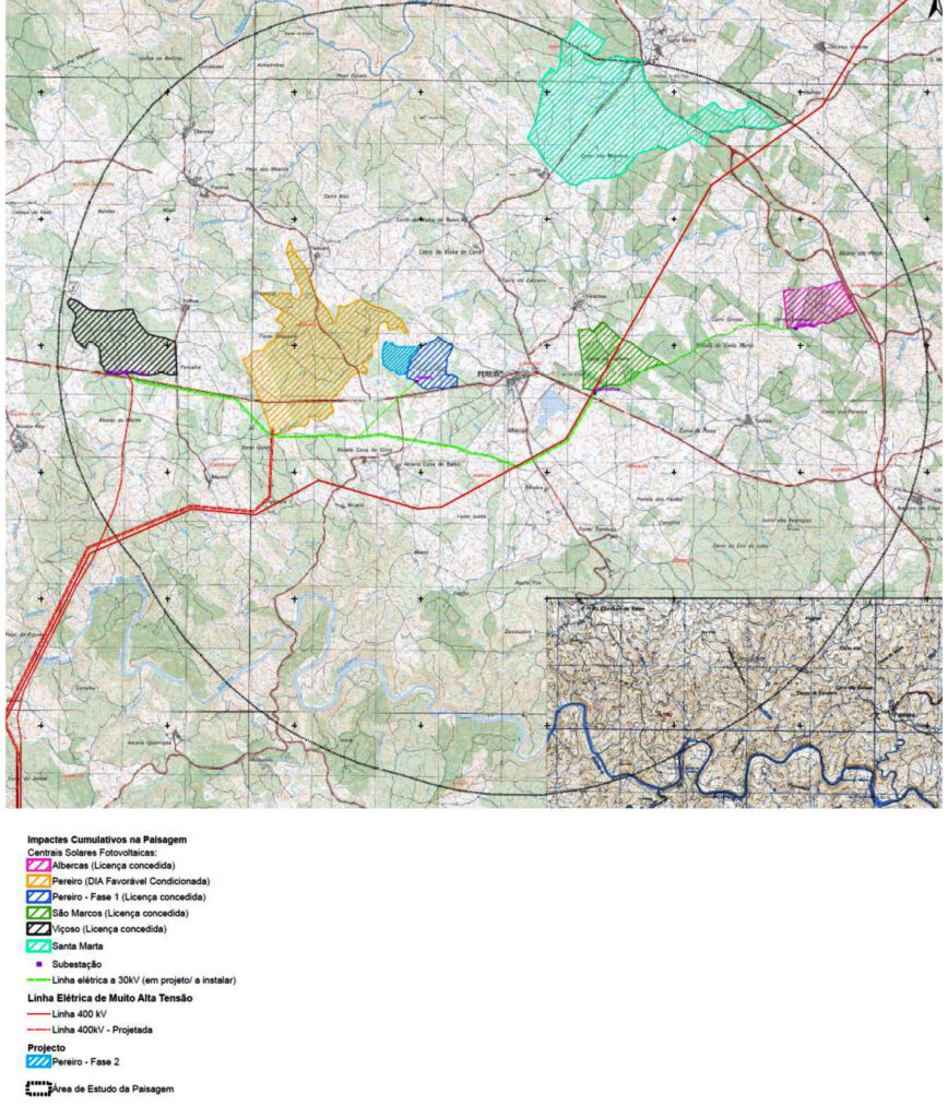
Existing projects in the surroundings
Pereiro Photovoltaic Power Station (Phase 1), also licensed and under construction, adjacent to the Pereiro Photovoltaic Power Station under study (to the east);
São Marcos Photovoltaic Power Station, located to the east of the Pereiro Photovoltaic Power Station study area, at a distance of 2 km, identified in the DGEG with process number 1380 and already with the license granted on 4/5/2018;
Viçoso Photovoltaic Power Station, located west of the Pereiro Photovoltaic Power Station study area, at a distance of 3,1 km and identified in DGEG with process number 1470;
Albercas Photovoltaic Power Station, located to the east of the Pereiro Photovoltaic Power Station study area, at a distance of 5,2 km, identified in the DGEG with process number 1368 and already with the license granted on 4/5/2018;
Santa Marta Photovoltaic Power Station, which is in the preliminary environmental studies phase, still without a power line layout.
Very High Voltage Line of the Tavira – Puebla connection, at 400 kV, which passes south of the Photovoltaic Power Station study area and parallels the Electric Line to be built between the supports P14 to P23, at an approximate distance of 20m;
Electric lines, at 30 kV, connecting the 30/150 kV Substation in Viçoso;
Viçoso-Tavira Line, at 150 kV, connecting the Tavira Substation (owned by REN, SA);
Very High Voltage Line at Alcoutim Power Station, at 400 kV.
Draft of the participation proposal
I, by name, CC or NIF, present my opposition to the project on the basis of the various impacts, but in particular the Cumulative Impacts.In the vicinity of the Project's implementation area (within a radius of 5 km), it appears that there are in the surroundings, namely licensed/under-licensing photovoltaic plants and electrical lines, of which we highlight the following projects:
Pereiro Photovoltaic Power Station, a project already licensed, located to the north of Barranco de Alcoutenejo and adjacent to the Pereiro Photovoltaic Power Station under study (to the west);
Pereiro Photovoltaic Power Station (Phase 1), also licensed and under construction, adjacent to the Pereiro Photovoltaic Power Station under study (to the east);
São Marcos Photovoltaic Power Station, located to the east of the Pereiro Photovoltaic Power Station study area, at a distance of 2 km, identified in the DGEG with process number 1380 and already with the license granted on 4/5/2018;
Viçoso Photovoltaic Power Station, located west of the Pereiro Photovoltaic Power Station study area, at a distance of 3,1 km and identified in DGEG with process number 1470;
Albercas Photovoltaic Power Station, located east of the Pereiro Photovoltaic Power Station study area, at a distance of 5,2 km, identified in the DGEG with process number 1368 and already with the license granted on 4/5/2018;
Santa Marta Photovoltaic Power Station, which is in the preliminary environmental studies phase, still without an electrical line layout.
Very High Voltage Line of the Tavira – Puebla connection, at 400 kV, which passes south of the Photovoltaic Power Station study area and parallels the Electric Line to be built between the supports P14 to P23, at an approximate distance of 20m;
Electric lines, at 30 kV, connecting the 30/150 kV Substation of Viçoso;
Viçoso-Tavira Line, at 150 kV, connecting the Tavira Substation (owned by REN, SA);
Very High Voltage Line at Alcoutim Power Station, at 400 kV.
At the landscape level; in flora and habitat; in the fauna, particularly with regard to the disturbance of calm patterns and the exclusion of some species, namely birds of prey and large mammals; at the socio-economic level, it is recognized that the existing and planned projects for Alcoutim municipality, together with the Project under analysis, could reduce the attractiveness of the place for residents and tourists, leading to a lower demand for tourist developments in the region and accentuating the trend depopulation that is already taking place in this municipality; on land use planning and conditions for land use will be related to the affectation of rural land (agricultural spaces, agroforestry spaces and natural spaces) and the disaffection of areas included in the National Ecological Reserve. (affectation of rock rose bushes in categories of agricultural, agroforestry and natural space, of the Alcoutim PDM).
Since there are already Impacts arising from the 1st phase on Water Resources, Soils and land use, Spatial Planning, Ecology, Landscape, Air Quality, Heritage, Socio-economy.
Hydrography
The Pereiro Photovoltaic Power Station Project, located in the municipality of Alcoutim, covering the parishes of Gioes and União of the parishes of Alcoutim and Pereiro and, in terms of nature conservation, it appears that part of the project area is located on the site Ramsar 3PT030 – Ribeira de Vascao, on the land of the Vascao and Foupana streams, respectively to the north and south of the study area, which constitute tributaries of the Guadiana river, at the head of the watersheds of the Cadavais stream and the Malheiro ravine .
The basin of the Ribeira da Foupana covers almost the entirety of the corridor, in about 9 m, with a break of 000 m, where the corridor is intersected by the basin of Ribeirao. dense hydrographic network, with small water lines that present a torrential and ephemeral flow regime, flowing only during periods of greater precipitation and drying up in the summer season, which feed small dams and ponds, forming permanent artificial water reservoirs .
The impacts on the hydrogeological system are related to the compaction of land, reduction of the infiltration area and the possibility of contamination due to accidental spills of polluting substances and the removal of existing vegetation and changes in land use, inherent to the massive placement of solar panels, constituting a significant negative impact of high magnitude.
Ecology
The project will affect the following occurrences regarding natural values in the presence:
i) Three habitats from Directive 92/43/EEC, as amended by Directive 97/62/CE – 6310 Montados de Quercus spp. evergreen, 91BO Thermophilic ashwoods of Fraxinus angustifolia and 92DO Southern riverside galleries and woods (Nerio-Tamariceta and Securinegion tinctoriae) – in good state of conservation and floristic diversity;
ii) Pure forest stands (montados) of Quercus spp., with a predominance of holm oak (Az);
iii) Pure stands of Pinheiro Manso and mixed stands of Pm with Az and cork oaks (Sb), in a very significant area, with direct and irreversible impact on the stands, which have not yet reached their term of exploitation and to which , important financial support from the State, from the installation phase to the state they present today, as well as the habitats and species that their installation provided;
iv) Az and Sb dispersed across agricultural and forestry areas;
Use of the soil
Thus, in view of the above, it is considered that the impacts on land use, in the construction and exploration phases, will be effectively negative and significant, taking into account that some of the plant communities that will be affected by the implementation of the project have conservationist values and /or ecologically important, namely due to the “considerable number of holm oaks and the disturbance of some segments of small watercourses, habitats identified in the study area with greater conservation value”.
Even the floristic communities that show a lower conservation status, given the considerable extent that will be destroyed (pine forests, mixed forest stands, scrubland and agricultural areas), will have a cumulative impact, which will translate into a globally negative impact, direct, of high magnitude, right, local, reversible in the long term and with meaning.
Territorial Planning
it is verified that the classification and use of the land foreseen by these instruments, namely by the PDM (Natural Spaces - Safeguard Areas and Biophysical Activation; Agroforestry Spaces - Multiple Use Areas; Mixed Areas and Protection Areas; Agricultural Spaces; Areas of Rural Housing), constitute spaces of safeguard, preservation of natural characteristics and environmental and landscape balance, with functions of framing and protection and potentiation of autochthonous vegetation.
In this context, it is considered that the impacts will be considered negative, direct and significant, although potentially reversible, in the long term (after deactivation, if it is carried out properly, and if the vegetation cover is recovered), since they change the intended use by this plan.
Has the recovery of vegetation cover in the area of the 1st power station and the Minimization and Compensation Measures been and are being complied with?
_ Compensation with mixed afforestation of stone pine and quercineas and enhancement of habitats 91BO and 92DO, in an area corresponding to that affected by the destruction of existing stone pine stands, which must be the subject of a Monitoring and Evaluation Plan, with a view to guarantee of the intended result of afforestation.
_ Recovery and Conservation Plan for the Aguia-de-Bonelli, in the Mata Nacional das Terras da Ordem (located approximately 12 km from the project area).


Comments