The rain returned this morning to some areas of the Alentejo Coast, the Barlavento Algarvio and, mainly, close to Greater Lisbon.
According to the Portuguese Institute of the Sea and Atmosphere (IPMA), after a sequence of hot and dry days, from the 17th of September (this Thursday) there will be a change in the meteorological situation, «with a gradual decrease in temperature and showers , which will sometimes be strong and accompanied by thunderstorms and affecting the entire territory of the continent».
IPMA stresses that "this situation will persist, at least until Saturday, 19 September."
The website Meteofontes, noting that the entire continent is under Yellow Warning, precisely because of the rain, adds that the rest of today «will be marked by a generally cloudy sky, with good openings in the south, and showers, sometimes strong and accompanied by thunder and hail", especially "near the west coast, in the morning, and in the interior North and Center, in the afternoon".
The wind will be light from the south, increasing in intensity to strong throughout the day.
The maximum temperatures will be around 24ºC in the interior of the Algarve and 23ºC along the southern coast, 25ºC in the interior of Alentejo, 26ºC in the Tagus Valley, 22ºC in the North Coast and 26ºC in the interior North and 26ºC in the interior Centre.
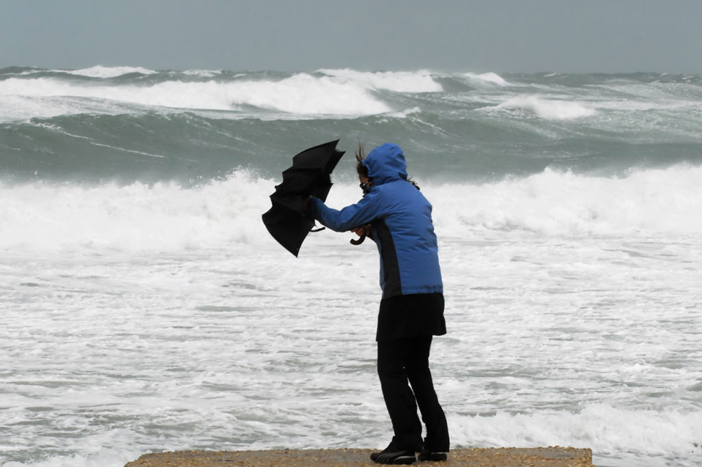
The swell will be SW of less than 1m on the South coast, and NW with 1,5m to 2m on the West coast.
For tomorrow, Friday, the IPMA draws attention to the maritime agitation on the south coast of the Algarve. Meteofontes points out that the swell, which will be from the Southeast with 2 to 3m on the South coast, and from the Southwest with 2m to 3m on the West coast, «will occur at the height of the New Moon, with the so-called “living tides”, whose height of high tide will be around 3,8m».
"This situation, together with the strong swell of Southeast and the depression near the Continent, could lead to a peak above the forecast at the time of that same tide and the occurrence of flooding in the riparian zones and some damage caused by the swell on the coast."
Tomorrow will also have a generally cloudy sky, with the occurrence of showers, sometimes heavy and accompanied by thunder and hail, during the morning and morning, more likely in the South region, and in the North and Center, in the afternoon.
The wind will be Moderate to Forte de Sul, with gusts around 80km/h especially in the South and Center.
The maximum temperatures will be around 23ºC in the interior of the Algarve and 23ºC along the southern coast, 25ºC in the interior of Alentejo, 22ºC in the Vale do Tejo, 23ºC in the North Coast and 24ºC in the interior North and 22ºC in the interior Centre.
On Saturday, there will be periods of cloudy skies in the North and Center and with some open in the South. Occurrence of showers and thunderstorms, more likely in the North and Center, but with some chance for the South as well. Wind Moderate to Strong South.
The maximum temperatures will be around 24ºC in the interior of the Algarve and 24ºC along the southern coast, 25ºC in the interior of Alentejo, 25ºC in the Vale do Tejo, 20ºC in the North Coast and 22ºC in the interior North and 22ºC in the interior Centre.
Swell decreasing, but still from Southeast with 1 to 2 m on the south coast and from SW with 1 to 2 m on the west coast.
On Sunday, the cloudiness should decrease in the south. The possibility of showers, accompanied by thunderstorms, will remain, especially in the north and center. Light to Moderate Wind from the west.
The maximum temperatures will be around 24ºC in the interior of the Algarve and 23ºC along the southern coast, 25ºC in the interior of Alentejo, 24ºC in the Vale do Tejo, 20ºC in the North Coast and 20ºC in the interior North and 19ºC in the interior Centre.
IPMA explains that “this situation will be caused by precipitation bands associated with a depression that will be located about 600 km north of Madeira (38°N 17.5°W) at 12UTC on Thursday, 17 September, and which will move to the east, becoming located about 200 km southwest of the Lisbon region (38°N 11°W) at 12UTC on Friday, 18 September».
The evolution of the depression and its nature has been monitored by the IPMA and the National Hurricane Center (NHC, responsible for monitoring tropical cyclones in the Atlantic), with a 20% probability of this extra-tropical depression becoming a depression. sub-tropical, that is, to acquire some characteristics that occur in tropical cyclones.
According to current information, this possibility is only restricted to a period of its trajectory over the sea and, therefore, without affecting the coastal regions of the national territory (mainland and islands).
However, due to the uncertainty associated with the weather forecast for this episode, IPMA recommends monitoring the forecast and weather warnings for the coming days by consulting the website http://www.ipma.pt/pt/otempo/prev.descritiva/
For more details on the forecast for maritime navigation please consult http://www.ipma.pt/pt/maritima/boletins/


Comments