The districts of Faro, Setúbal, Lisbon, Leiria and Beja will be, between Thursday and Friday, under orange warning due to the forecast of strong maritime unrest, the Portuguese Institute of the Sea and Atmosphere (IPMA) said today.
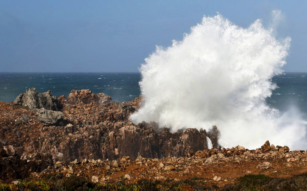
More serious is the level of warnings in the districts of Porto, Viana do Castelo, Aveiro, Coimbra and Braga, which will be under red warning between 09:00 on Thursday and 09:00 on Friday, due to the forecast of “northwest waves measuring 7 to 8 meters, reaching a maximum height of 14/15 meters”.
The orange warning of maritime unrest for Lisbon and Leiria is valid between 06:00 on Thursday and 15:00 on Friday, while Setúbal, Faro and Beja are under the same alert between 15pm on Thursday and 00pm on Friday.
The Madeira archipelago is under yellow warning due to sea unrest, with northwesterly waves measuring 4 to 5 meters expected between 21pm on Thursday and 00pm on Friday.
The IPMA also placed the districts of Porto, Viana do Castelo and Braga under yellow warning due to the forecast of rain or showers, sometimes heavy, between 21:50 pm today and 03:00 am on Wednesday and between 18 pm: 00 on Wednesday and 03:00 on Thursday.
Viseu, Guarda, Santarém, Leiria, Castelo Branco and Vila Real are also under yellow warning due to heavy rain between 00:00 and 03:00 on Wednesday and between 00:00 and 06:00 on Thursday -fair.
The red warning is the most serious on a scale of three (red, orange and yellow).
The orange warning is issued by IPMA whenever there is a “moderate to high risk meteorological situation and yellow when there is a risk situation for certain activities dependent on the meteorological situation”.
The National Emergency and Civil Protection Authority (ANEPC) today issued a warning to the population about the worsening of weather conditions in the next 48 hours, with wind and heavy rain, sea disturbances and snowfall.
Based on forecasts from the Portuguese Institute of the Sea and Atmosphere (IPMA), ANEPC warns of the occurrence on Wednesday of periods of rain or showers, sometimes heavy, north of Cabo Mondego in the morning and on the North coast, from the end of the afternoon, as well as persistent precipitation in the mountainous regions of Minho and Douro-Litoral, which can exceed 40 millimeters (mm) in six hours.
Strong winds are forecast for the same day, with gusts of up to 70 km/h on the North coast, which at the end of the day can reach up to 90 km/h in the North and Center, associated with sea disturbances on the west coast, north of Cape Raso , with waves of four to five meters.
For Thursday, ANEPC warns of a similar scenario, with periods of rain, sometimes heavy, to the north of the Montejunto-Estrela mountain system until early in the morning, changing to showers in the afternoon, and the possibility of falling of snow above 1200/1400 meters altitude.
Forecasts for Thursday also point to strong winds in the northern and central highlands, with gusts of up to 100 km/h and strong sea agitation south of Cape Raso, with waves measuring five to seven meters and reaching 14 meters in height. .


Comments