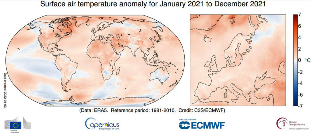
The year 2021, globally, according to the Copernicus Climate Change Service (C3S), is part of a cycle of seven consecutive years of record temperatures, the Portuguese Institute of the Sea and Atmosphere (IPMA) has just announced.
Globally, 2021 was the 5th-fifth warmest year, slightly surpassing the values of 2015 and 2018. The warmest years were 2020, 2016, 2019 and 2017.
The year 2021 had an anomaly of + 0.47 °C compared to the normal 1981-2010 with regard to the annual average air temperature.
Interestingly, despite being the hottest European summer ever, in Europe, the year 2021 is not among the 10 hottest, with an anomaly of + 0.59°C in the average air temperature compared to the normal 1981- 2010.
Last summer, in the Mediterranean area (mainly Greece, Spain and Italy), there was an intense heat wave, with very high air temperatures, drought and violent fires. A record air temperature was recorded in Sicily, 48.8 °C more 0.8 °C than the previous maximum.
Regarding precipitation in Europe, during 2021, there was a lot of rain in some parts of the continent and drought in others.
Thus, points out the IPMA, above-average values were recorded in large parts of Western and Central Europe and in parts of southern Europe, but drier than average in parts of the Iberian Peninsula, and in the easternmost regions of Europe, including southwestern Russia, Caucasus and Turkey.
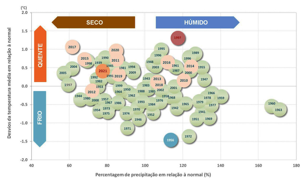
In mainland Portugal, the year 2021 was classified as hot and dry. The mean annual value of the mean air temperature in 2021 was 0.41 °C higher than the normal value 1971-2000.
The mean value of the maximum air temperature was the 12th highest since 1931, with a deviation of +0.81 °C and the mean value of the minimum air temperature was very close to the normal value.
Relevant weather events in 2021 in Portugal:
♦ “Hortense” Depression – January 21st and 22nd: intense precipitation, strong gusts of wind, above 100 km/h in the North and Center regions, especially in the highlands. The highest gust values were recorded in Caramulinho (1003 m), 124 km/h and in Pampilhosa da Serra (836 m), 123.1 km/h.
♦ Snow Episode – January 9: occurrence of snow in the interior at very low altitudes, of the order of 250/300 m, especially in the Alentejo.
♦ Very cold weather in January (1 to 19): generalized cold situation throughout the territory with maximum and minimum air temperature values much lower than the climatological normal value:
o Persistence of several consecutive days with negative temperatures (+ 10 consecutive days in 1/3 of the seasons) in particular in the North and Center regions.
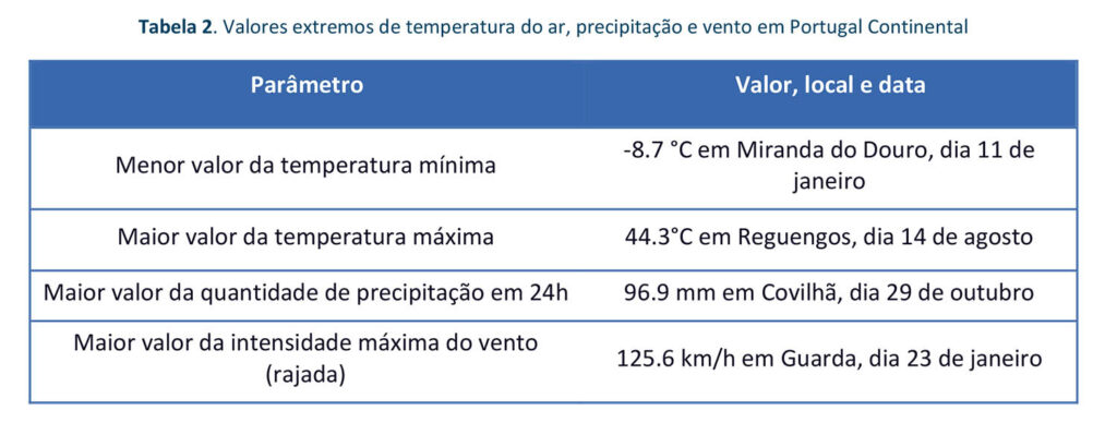
o After the lowest minimum air temperature values were exceeded in the stations of Chaves, Braga and Covilhã (stations with series starting after 1990), in which this episode of cold must have been more intense, as new extreme values were recorded: -8.3 °C, -7.0 °C and -6.4 °C, respectively.
o Cold wave: despite the occurrence of a cold wave, it was relatively localized and occurred in about 10% of the meteorological stations.
o Thermal discomfort associated with low air temperatures (in some days enhanced by the intensity of the wind).
♦ February the 5th warmest since 1931: the mean value of the mean air temperature was +1.68 °C higher than normal. The average minimum air temperature was the 3rd highest since 1931, with an anomaly of +2.35 °C.
♦ Heavy rainfall in February:
o Days 4 and 5 – some low pressure situations caused intense precipitation in the southern region, accompanied by thunderstorms. The highest values were exceeded
daily (00-24h) in the meteorological stations of Portel and Faro.
o February 9th and 20th – frequent, intense and generalized precipitation in the territory, especially in the North and Center regions; very high daily values, having been exceeded the highest values (00-24h) in some stations in the North and Center of the territory. On the 20th, the passage of a cold frontal surface of strong activity associated with the Karim storm, generated gusts of the order of 100 km/h on the coast and 110 km/h in the highlands.
♦ Hot weather in March: daily values of very high maximum air temperature between 14 and 18 and from the 22nd, which highlights the period from 28 to 31 with deviations greater than 6 °C from the normal:
o On the 31st, the highest maximum temperature values were exceeded in some meteorological stations in the North and interior South regions, with emphasis on Elvas (30.1 °C) and Aveiro (29.8 °C), stations with long series, since 1941 and 1981, respectively. .
o From the 29th to the 31st, the highest minimum air temperature values for the month of March were exceeded in the stations of Cabril, Macedo de Cavaleiros, Coimbra, Tomar, Alvega, Almada, Sines and Odemira.
♦ “Lola” Depression – April 23rd to 28th: occurrence of intense, locally heavy precipitation, sometimes accompanied by hail and thunderstorms.
♦ May with very low daily minimum temperature values: the daily values of the minimum air temperature were almost always lower than the monthly mean value; on day 2, the lowest values of minimum air temperature were exceeded in some meteorological stations, with emphasis on Alvega (1.2 °C), Elvas (3.4 °C) and Neves Corvo (4.0 °C) stations with long series since 1949, 1941 and 1981, respectively.
♦ Heavy showers, hail and thunderstorms on the 31st of May: northeast region of the territory, especially in the region of Montemuro-Alvão-Castro – Lamego, with 15.1 mm recorded in one hour in Pinhão.
♦ Severe weather phenomena in June: occurrence of heavy precipitation between the 11th and 20th, especially in the North and Center regions, accompanied by hail, thunderstorms and strong convective gusts of wind. Locally intense gusts of 50 to 70 km/h were recorded in some places in the interior of these regions. In Pinhão, gusts between 79 and 103 km/h were recorded on the 15th.
♦ Very hot weather August 10th to 17th:
o Due to the transport of hot and dry air to the territory, very high maximum air temperature values occurred, especially on days 13 to 15 with about 10 to 20 % of meteorological stations recording values above 40 °C (days extremely hot); the highest value of maximum temperature occurred in Reguengos, 44.3 on the 14th.
o Tropical nights (minimum air temperature values ≥ 20 °C) in more than 10% of the stations from the 13th to the 17th, particularly in the South region, namely in the Algarve, where the 14th stands out with more than 30% of the stations .
o Heat wave lasting between 6 and 9 days in the interior regions of the North and Center, Vale do Tejo and in some places in the Alentejo.
♦ Heavy showers, hail and strong wind in September: there were conditions of instability over the mainland, with the occurrence of showers, sometimes strong and accompanied by thunderstorms, as well as locally intense wind gusts, with greater frequency and intensity in the Center region and some places in the South region.
♦ Hot weather in October: persistence of maximum air temperature values almost always above the normal value, highlighting the periods from 6 to 15 and 18 to 21. There was a heat wave lasting between 6 and 10 days in some places in the Tagus Valley regions and Alentejo.
♦ Heavy Rainfall – October 29 and 31: precipitation, sometimes persistent and strong to very strong in the North and Center regions and on day 30 in the Center and South regions. The highest daily values of precipitation were exceeded in some stations in the Center region.
The wind sometimes blew strong along the coast, with gusts of up to 95 km/h at Cabo da Roca and Fóia stations.
♦ Very hot December: 4th warmest December since 1931; maximum air temperature, the 2nd highest since 1931. Of note was the 31st, which was exceptionally hot, having exceeded or equaled the respective previous December maximums in about 10% of the mainland stations. Zambujeira recorded a value of 26.4 °C which is a new maximum for this season and constitutes a new extreme for the month of December in mainland Portugal since 1941.
♦ Meteorological Drought: between April and late August, a gradual increase in the area and in the intensity of the meteorological drought. On September 30, the area was reduced to drought, ending the hydrological year with 43% of the territory in meteorological drought. In the months of November and December, there was a further increase in the area and in the intensity of the drought, ending the year with 94% of the territory in a situation of meteorological drought (58% weak drought, 27% moderate drought and 9% severe drought) .


Comments