Showers, maximum temperatures between 17 and 24 degrees and dust from North Africa. This is the weather forecast from the Instituto Português do Mar e da Atmosfera (IPMA) from today until Carnival Tuesday.
According to the IPMA, until Tuesday, the weather in mainland Portugal will be conditioned by a depression centered southwest of the Iberian Peninsula.
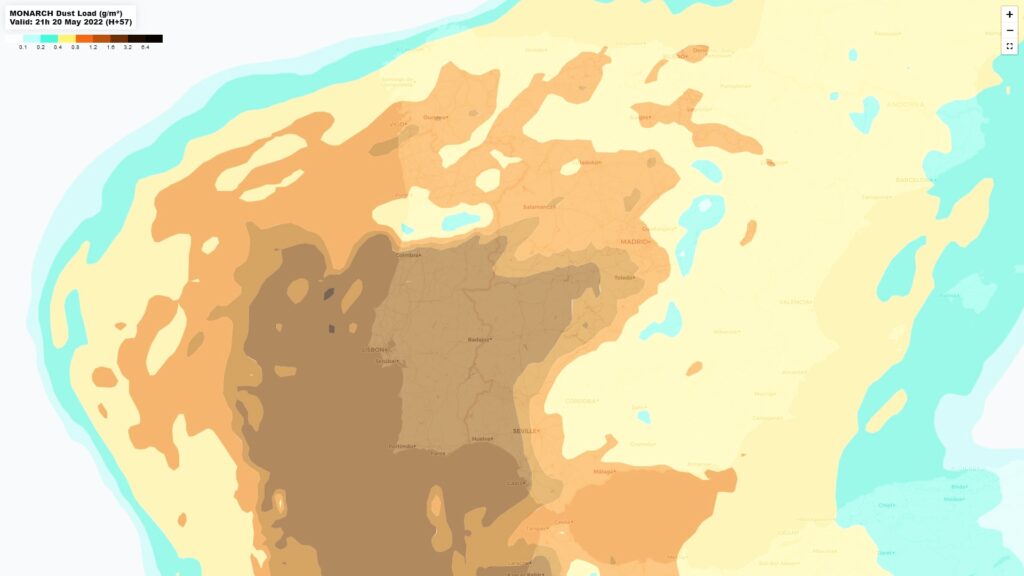
Due to the depression, the transport of dust suspended in the atmosphere over the continent from North Africa is expected, which should have low concentration, but may increase temporarily between the end of the day on Saturday and Sunday.
As of today, an increase in cloudiness is also expected, with the possibility of showers in the Algarve In the end of the day.
On Saturday, the showers will be in the southern region, and may extend to the central region from the afternoon onwards. On Sunday, the showers will be weak and infrequent, increasing in frequency on Monday and Tuesday, and on these days they may also occur in the northern region.
“This meteorological situation has some associated uncertainty mainly due to the position of the mentioned depression. It should be noted that the shower regime presupposes intermittent and dispersed precipitation, both spatially and temporally”, says the IPMA in a statement.
As for temperatures, the IPMA indicates that they will suffer small variations, with the minimum values between 08 and 13 degrees Celsius on the coast and between 06 and 09 degrees inland, being slightly lower, between 03 and 6ºC, in the interior North and Beira High.
Maximum temperature values will be higher than normal for the time of year, between 17 and 24 degrees in most of the mainland.
The wind will be light to moderate, blowing moderate to strong in the Algarve Saturday and in the highlands, especially in the Center and South regions.
The IPMA also predicts maritime agitation, with waves from the southeast on the south coast Algarve with 1 to 2 meters, between 2 and 2,5 meters today and Saturday.
For the Madeira archipelago, periods of cloudiness and showers are expected, especially on the northern slopes and in the highlands.
On Monday and Tuesday, the probability of precipitation decreases and the showers, if they occur, will be generally weak.
Moderate to strong wind is also expected and maximum temperatures between 16 and 22.
In the Azores, between today and Monday, cloudiness is expected but alternating with open ones on all the islands, significant precipitation is not expected.
On Carnival Tuesday, the “approach and passage of a cold frontal surface with undulations, with slow movement and moderate activity” will affect the weather on all islands, starting with the islands of the Western Group and gradually extending through the rest of the Azores archipelago.
Thus, an increase in cloudiness is expected with periods of light rain changing to light showers and, only on the Fores and Corvo islands, a slight increase in wind intensity.
The maximum temperatures will vary between 15ºC and 17ºC.


Comments