The Strategic Environmental Assessment (AAE) of the Hydrographic Region Management Plans (PGRH) and Flood Risks Plans (PGRI) of the Ribeiras do Algarve Hydrographic Region is the subject of public debate since yesterday, the 2nd of February, and until the 15th of March.
The Hydrographic Region Management Plans (PGRH) and the Flood Risk Management Plans (PGRI) are subject to the SEA process, since they fall within the water management sector.
The participation of those interested in this phase of public discussion of both plans can be done through the Participa.pt portal, clicking here. This is where all the documentation that will allow you to carry out the assessment is available.
The Ribeiras do Algarve PGRH (RH8) for the period 2022-2027 (3rd planning cycle), defines the necessary measures to achieve the environmental objectives, that is, to reach the good condition or the good potential of the water bodies.
O Non-Technical Summary clarifies that the PGRI of Ribeiras do Algarve for the period 2012-2027 (2nd planning cycle) «was developed in close articulation with the PGHR and, in accordance with the provisions of the Flood Directive, identified the critical areas, prepared the respective maps of flood and flood risk zones and the respective prevention, preparation, protection and recovery measures in relation to the effects of floods".
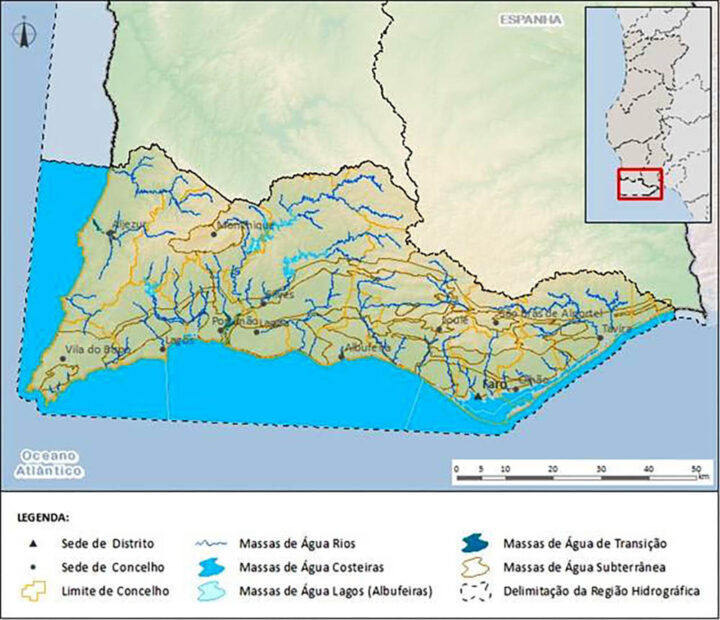
The Ribeiras do Algarve Hydrographic Region – RH8 has a total area of 5 511 square kilometers (km2) , it integrates the watersheds of the Algarve streams including the respective groundwater and adjacent coastal waters.
The RH8 encompasses, totally or partially, 18 councils, 10 of which are fully included in the RH and 8 are partially covered.
The municipalities fully covered are Albufeira, Aljezur, Faro, Lagoa, Lagos, Monchique, Olhão, Portimão, Silves, Vila do Bispo, while those partially covered are Almodôvar, Odemira, Ourique, Castro Marim, Loulé, S. Brás de Alportel, Tavira and Vila Real Santo António.
The main water courses in the hydrographic region originate in the mountains of Monchique and Espinhaço de Cão, to the west, and in the Caldeirão in the northeast sector, the most important being the Arade river.
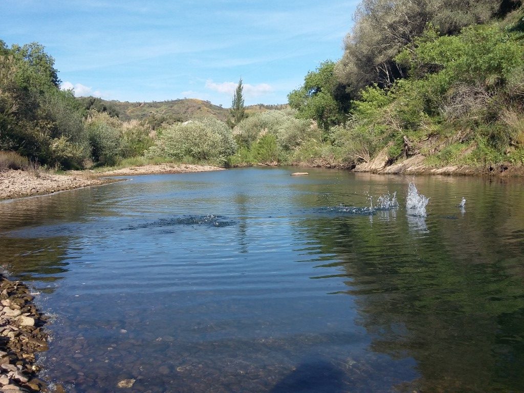
The documents under discussion point out that «most watercourses have a torrential regime with zero or very low flows during part of the year, corresponding to the dry season».
The Arade river, with its sources in the Serra do Caldeirão, lines up in the contact between the schist mountain range and the limestone barrocal in the region of Silves.
The Algibre stream covers practically all of its extension limestone formations, runs east-west, taking advantage of the alignment of the Alportel fault, flowing westwards to the confluence with the Quarteira stream.
The Alportel stream, like the Algibre stream, features an extensive stretch aligned in a west-east direction.
The Odelouca stream, which rises in the Serra do Caldeirão, after an initial stretch running east-west, with vigorous slopes carved into the schist surface, turns southwest to skirt the Serra de Monchique and in the final stretch flows south towards the estuary of the Arade river.
About 15 kilometers before the confluence with the Arade river, the valley widens considerably, although it maintains steep slopes. This stream crosses, for most of its length, schist formations.
With regard to the Management Plan for the Ribeiras do Algarve Hydrographic Region, in this 3rd cycle the description of the RH8 was updated, namely in terms of the delimitation of bodies of water (surface and underground), protected areas, significant pressures, assessment the status of water bodies, availability and water needs.
81 surface water bodies were identified (of which 72 are natural, 8 are heavily modified and 2 artificial) and 25 groundwater bodies.
The main pressures, as can be seen in the following table, are the 57 rejections of urban WWTP, of which 63% result from more advanced secondary treatment. That is, 43% still do not have this type of treatment.
There is also the water rejected by the production and crops of horticultural products in the Sotavento Algarve, which represents 87% of the total load of rejects by the food industry.
According to the Plan's data, the situation is more significant in the Sotavento sub-basin, which «is the most pressured [in the whole of the Algarve] by rejections from the food and wine industry, with 97% of the total load rejected».
As for the impacts of tourism and activities linked to it, the «Barlavento sub-basin is the most pressured», since the sector of sports, entertainment and recreational activities, which includes water and theme parks and a racing track, contributes 72 % of the total load rejected by tourist developments.
In terms of water collected for various purposes in the Ribeiras do Algarve Basin, «67% of the volume collected is for agriculture and 22% for public supply».
The basin is still under many «hydromorphological pressures», which involve the «implantation of obstacles, alteration of the hydrological regime and changes in the physical characteristics of the surface water bodies», as a result of the existence of «2712 dams and weirs, of which 9 are large dams (height > 15m); 9 alterations of the bed and margins (8 regularizations and 1 canalization); 3 dredging and 1 artificial beach feeding; 43 coastal interventions (of which 14 spurs, 14 breakwaters, 7 pontoons and 1 breakwater stand out); 27 structures to support navigation in transitional and coastal waters; 357 bridges and 27 viaducts; 109 dikes and 165 gates; 10 tubes; 3 port facilities'.
With regard to biological pressures, the documents identify 50 exotic species, of which 42 are invasive. Most of them can be found in inland waters (37 exotic species, all invasive), highlighting the presence of sugarcane, Louisiana red crayfish, sun perch and gambusia.
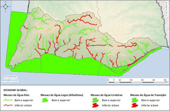
As for the status of the existing surface water bodies in this RH, it appears that about 62% have an overall status of Good and Superior and about 38% have an overall status of Less than Good.
With regard to rivers, 61% of them are classified as Good or Superior. The reservoirs, on the other hand, present, in their entirety, a Good and Superior global status.
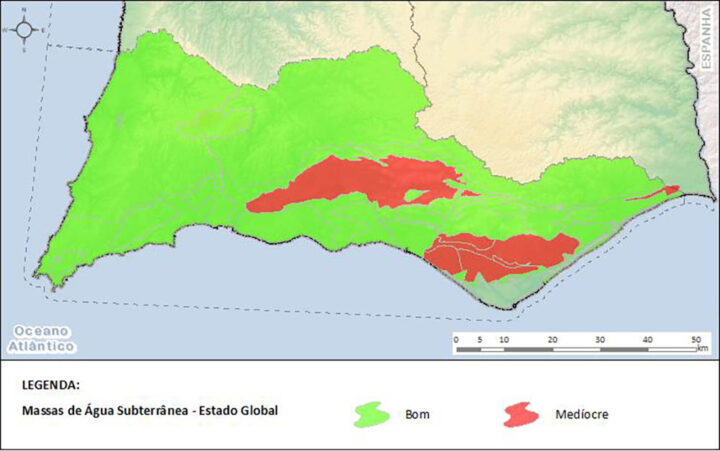
More worrying is that 62,5% of groundwater bodies (aquifers) have a Mediocre global status, as can be seen in the figure above. The aquifers of the so-called Campina de Faro and Querença-Silves are heavily affected.
Anyone who wants to analyze the documents and participate in this Strategic Environmental Assessment of the Hydrographic Region Management Plans (PGRH) and Flood Risks (PGRI) of the Ribeiras do Algarve Hydrographic Region, can click here to access the Participa.pt portal.


Comments