Digital territories open the way for another perspective of looking at the problems of urban and territorial development.
In this way, I am suggesting that the conventional mapping of making territory gives way to another less conventional and more virtual cartography of drawing territorial cartography, that is, I am suggesting that there may be several cities in the same city and, thus, the to add reality to the existing reality, thus creating a new opportunity for the development of territories. As the table below shows.
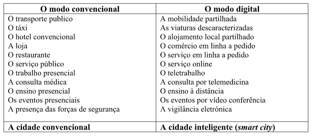
The conventional mode has a certain georeferencing or territorial cartography, if we like, a more fixed pattern of mobility, but also a more physical and in-person mode of sociability and communication, if we like, more emotional. The algorithmic or digital mode has a different georeferencing, a flow-pattern and a more mobile cartography, as well as a more intangible and virtual sociability and communication.
If we observe the two modes of occupation of territory through the prism of the three intelligences (rational, emotional and artificial) we will see that emotional intelligence clearly loses out when we move from conventional to digital mode. Now, it is emotional intelligence that best embodies both the occupation of the territory and our relationship with nature, and the sentimental provision for human communication and sociability.
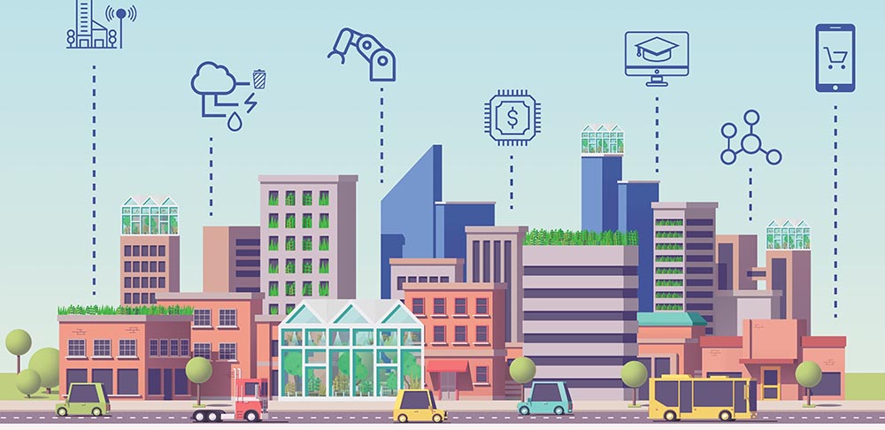
Now, this finding is full of consequences when we look at the planning policy and urban planning of large cities, because in the same city we have two significant universes in deep interaction.
As if they were two cities in the same city: the universe of material and tangible problems that need to be digitized and virtualized (the virtualization of reality) and the universe of virtual imaginaries (virtual realism) that also awaits to be converted into reality tangible and material and many other real communities.
In this two-speed city, it remains to be seen how the respective territorial cartographies and representations of public space evolve, how the so-called green spaces are accommodated, what is the adequacy of urban architecture to this double speed and how our mobility pattern is distributed in this context.
The modes and platforms, between the in situ and ex situ
In the conventional way, citizens will have services that are physically established in the places of residence according to a certain urban geography. The routes are familiar: the kiosk, the bookmaker, the café, the shop, the public service, the bank branch, the CTT post, the pharmacy, the bookstore, the library, the office, the restaurant, the gallery, the conference room, among many other venues.
In digital mode and, in many cases, it is the services that come to us, online and on our smartphone terminal: the online newspaper, the online game, online shopping, online ordering, the e-government and e-banking, the meal uberized takeaway, telework and telemedicine, digital visits to museums and galleries, the e-book, events on social networks, the webinars, between others. It seems, therefore, that the fixed became a flux.
In addition, Covid-19 forced a reconsideration of displacements, concentrations, services, leisure and recreation spaces, the sports universe, the urban architecture of the public space, that is, everything that concerns the occupation and distribution throughout the territory. It is still too early to realize the impact on the ways of organizing the city, but nothing will remain the same.
In the conventional way, the city is vertical, power is centralized and dominates the city. The universe that prevails is the universe of equipment, infrastructure and public services, that is, the universe of public authorities. In digital and algorithmic mode, the code dominates the city, the city is more horizontal, collaborative platforms share power, a more lateral power that, under certain conditions, does not require the intermediation of public authorities.
We are not talking about a dual city, but about public, private and cooperative platforms that are still looking for a collaborative basis of understanding. When they reach this goal, we will surely have another cartography, another mobility pattern, another public-space territory.
On a technical level, platforms, algorithms and applications will create two distinct but complementary realities: activities , of direct physical presence and activities ex situ remote control and monitoring. Of course, the action plans will always comprise the two activities in varying dosages according to the respective planning.
On a more substantive level, however, reality , it is a cognitive space where the local community still has some capacity for observation-action and, therefore, for dialogue and communication. This ability can be lost from the moment when new digital devices take over the occurrence and start monitoring ex situ.
From that moment on, the language of the alphabet of human communities will progressively give way to the codified language of artificial intelligence (internet of objects). Henceforth, the data that record our passage, our personal traceability, will be the basic raw material for platforms and algorithms. We are no longer a citizen customer member of a local community to be a file, a password, an account number or a numbered notification.
In terms of mobility and spatial planning, it is obvious that everything depends on a healthy complementarity between the two perspectives. in situ and ex situ. The logic of platforms and algorithms is a groundless logic with a front office of intermediation much more reduced, while the logic , is a more administrative logic and with a front office more numerous presence. For example, the citizen's store has already changed the cartography of public space that was, before, more dispersed, the extension of online services will further modify this territorial cartography. The concept of “public administration of the territory” as we know it until now is truly at stake.
Final Notes
In summary, we need, above all, good institutional and collective intelligence to link the various incumbents present, and this is an essentially political task. Next, we need a good digital strategy that takes care of territory coverage and users' digital literacy, with a view to building a solid territorial intelligence, since good digital coverage is crucial for a territory to have a relevant production and collecting data about your own condition.
Then we need a good government of the commons, for example, an inter-municipal community, and a shared digital resource center. Finally, a course and a broad horizon that only a digital agenda can provide, since there is no algorithmic calculation capable of correcting discrimination or gaps in public intervention policies.
Finally, let's hope that digital coverage deficits do not herald the virtual death of the most disadvantaged territories. Now, it is the active principle of the networks that it is important to apply. We cannot allow the old problems of territorial cohesion to be added to the new problem of the digital fracture of territories. Now is the time for digital connection, collective intelligence, distributed platforms, collaborative society and territories and network actors. Nothing will ever be the same.
Author António Covas is a Retired Full Professor at the University of Algarve


Comments