 On Sunday, November 1st, in many parts of the Algarve, «it rained in a few hours (around 9 hours) more than usual for the entire month of November», says Bruno Gonçalves, environmental engineer and amateur meteorologist, responsible for the website and for the two seasons Meteophons, from the Chamber of Lagoa.
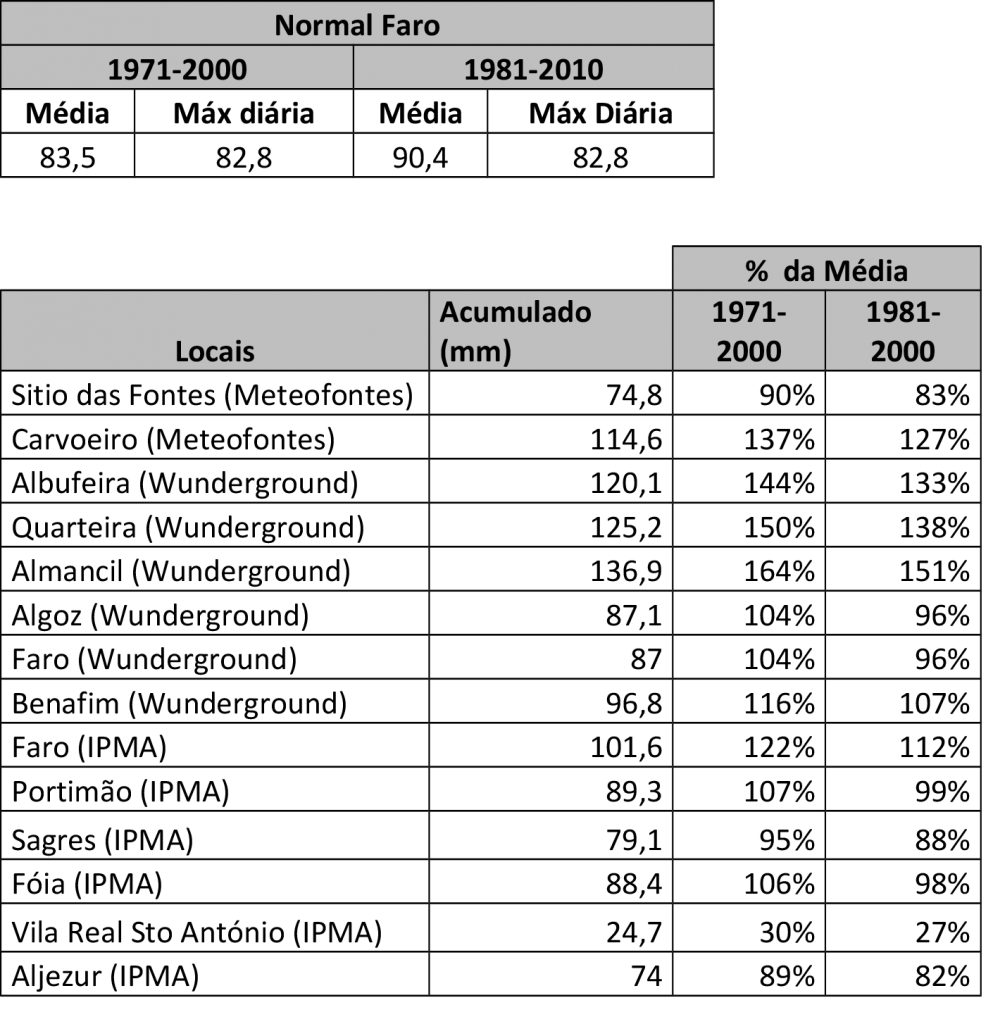
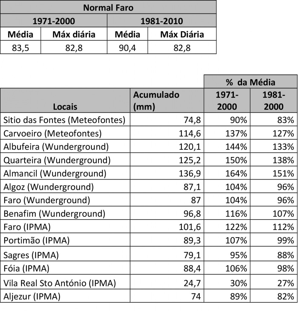
Thus, based on data from the weather stations of the Meteophons, from the website Wunderground (where are the data from some of the existing amateur stations in the Algarve – although its reliability is not known for sure) and also from the IPMA network itself, it can be concluded that, for example in Almancil, where it was on Sunday recorded the highest rainfall (136,9 mm), it rained 164% more than the normal average for that month at the weather station. Faro. Average, in the period between 1971 and 2000, was 83,5 mm and between 1981 and 2010 was 90,4 mm.
Sunday's storm, which caused flooding in several places in the region, «was an event characterized not exactly by the intensity of precipitation (the hourly values were within return periods of 2 to 5 years), but more by the duration of high values of precipitation, which persisted for about 9 hours (whose accumulations relegate to return periods of over 100 years)», added Bruno Gonçalves, who is also one of the founders of Troposphere, Portuguese Association of Amateur Meteorology.
So many hours of rain, a lot, without stopping, ended up saturating the soils, which could no longer absorb more water and from there to the floods was a small step. «After an initial period of continuous precipitation (between 04 am and 00 pm), which contributed to the saturation of soils and runoff networks, the final peak of precipitation between 13 pm and 00 pm ended up causing everything that was to spill over watercourse and rainwater drainage network, with the known effects arising therefrom'.
«If there are constructions – buildings, towns, cities – on top of water lines or flood beds, the result is always favorable to water…», emphasizes Bruno Gonçalves.
The Portuguese Institute of the Sea and Atmosphere (IPMA) has also just released the data and its assessment of the Sunday storm, which, stresses that body, affected «the region of the Barlavento Algarve during the period between 4 and 14 UTC [4:00 and 14:00), with particular incidence in the area between Portimão and Faro, causing heavy and persistent precipitation and the occurrence of thunderstorms».
However, the IPMA analysis, which uses only data from its two meteorological stations of Faro and from Portimão, it focuses more on the rain accumulated in one hour, to find out whether or not the “historic highs” were surpassed. And the conclusion is, they weren't. But the fact that it rained so much, for so long, did not cause problems any longer, although the IPMA analysis chooses not to go there.
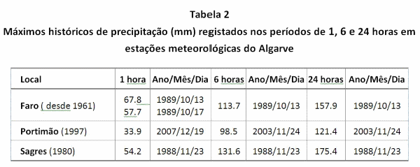
The conclusion of the official Portuguese meteorological body is that «at the station of Faro-Airport, the historical maximum hourly is about 3,4 times higher than that observed in this episode and the historical maximums of 6 hours and 24 hours are about 1,5 times higher than those observed».

As for the Portimão station, adds the IPMA, "the historic hourly and 6-hour peaks are around twice as high as those observed in this episode and the 2-hour historical peak is around 24 times higher than the observed."
But the main problems didn't even occur in Faro, not in Portimão, but especially in the municipalities of Albufeira and Loulé. As for these zones, the IPMA only makes estimates of what it will have rained, since it does not have an official meteorological station there.
Even so, he concedes that «considering the estimates obtained with radar for the period between 4 and 14 UTC, it is possible to admit that the highest values observed in Faro-Airport and Portimão have been exceeded in the coastal zone between Albufeira and Quarteira».
The IPMA explains, in a statement it has just released, that “the meteorological situation on the surface at 00 UTC on 1 November 2015 was determined by a depression with 1013 hPa centered in North Africa, in the process of digging, which, in the its movement to the northwest, came to position itself at 12 UTC in the region of Faro with 1009 hPa and, at the end of the day, in the Atlantic southwest of Cabo Raso (38ºN 10ºW), where it reached a minimum of 1005 hPa».
«Associated with this depression, organized lines of precipitation were formed, oriented from southeast to northwest, which in their slow movement to the north affected, mainly, the region of the western Algarve».
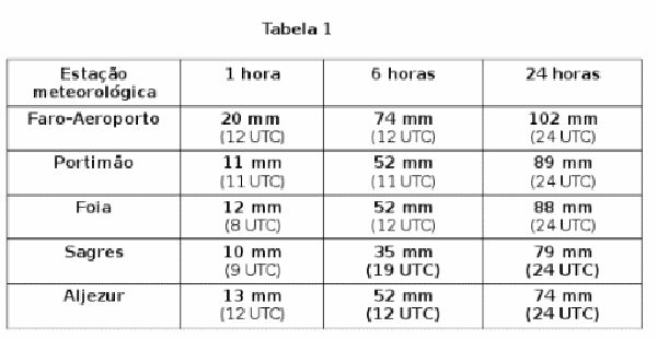
«In the automatic meteorological stations (EMA) of the IPMA network close to the most affected zone, the maximum hours of precipitation observed were 11 mm in Portimão at 11 UTC and 20 mm in Faro-Airport at 12 UTC, at this station, a maximum value of 74 mm was recorded in 6 hours, between 6 and 12 UTC».
"As the precipitation lines progressed to the north, they gradually lost activity, reaching the rest of the southern and central regions, but already with much less significant amounts of precipitation."
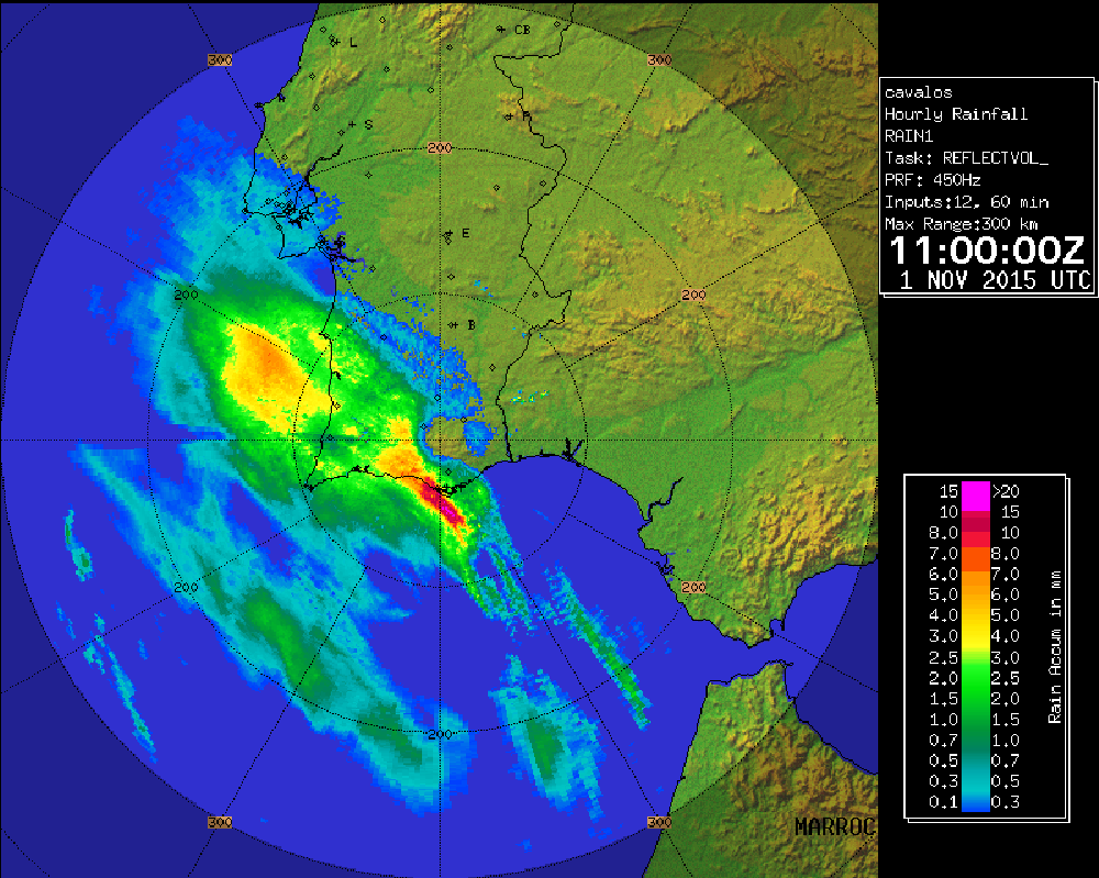
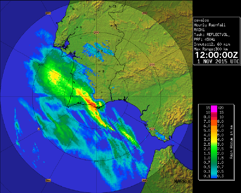
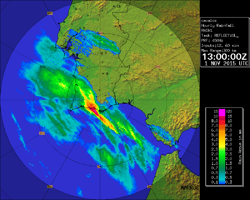
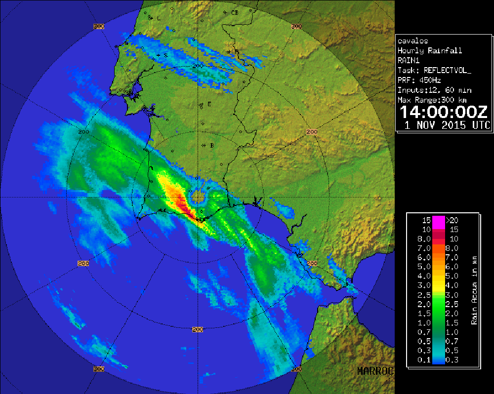
«The sequence of images of the RAIN1 radar product (hourly precipitation values in mm, estimated using the Loulé/Cavalos do Caldeirão meteorological radar), obtained for the period between 10 and 14 UTC, highlights the most affected area by the precipitation line, located between Portimão and Olhão».
It is based on these images and on the estimates obtained with radar that the IPMA admits that, in the coastal zone between Albufeira and Quarteira, it must have rained more than the «higher values observed in Faro-Airport and Portimão».
Even so, «by applying the Udometer-Radar adjustment factors obtained in the location of the EMA of Faro-Airport and Portimão, it is estimated that the amount of precipitation occurring between 4 and 14 UTC, in Albufeira and Quarteira, varied between 106 mm and 139 mm, with an estimated average value of 122 mm».


Comments