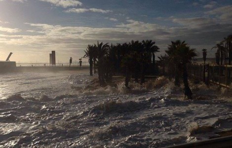
 was the call perfect storm, in which everything that could go wrong went wrong. This is the conclusion that can be drawn from the information provided by the Portuguese Institute of the Sea and the Atmosphere (IPMA) on the storm in the North Atlantic, from 3 to 6 January, which caused damage throughout the Portuguese coast, namely in the Algarve.
According to the IPMA, in addition to the high waves – in Sines a wave measuring 13,5 meters was recorded -, the wave orientation – from west and northwest WNW – also contributed to the greater degree of destruction in coastal areas, to which finally joined the high tide at high, "coinciding with the reports of flooding and destruction of bathing structures in different areas of the Portuguese coast, since the high tide makes the break occur closer to the coastline".
The IPMA points out that, since mid-December 2013, “the depressions originating in the eastern part of the USA have undergone rapid digging processes – explosive cyclogenesis – in their passage through the North Atlantic”.
This "intense digging of the depressions was essentially due to the strong contrast between the very cold air mass over the eastern part of the US and the warm, moist air mass of the Atlantic".
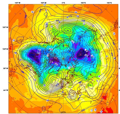
The Northern Hemisphere weather chart of Figure 1 shows the ECMWF (European Center for Medium-Range Weather Forecast) weather forecast analysis of January 3, 2014 at 00UTC (Coordinated Universal Time), of the air temperature at 850 hPa (~1500m) (ºC, Color) and contour lines at 500 hPa (~5500 m). In this figure, according to IPMA, it is possible to identify the meanders of the polar vortex and cold air pockets in which the air temperature, at about 1500 meters of altitude, was below -32 ºC (marked in very dark blue).
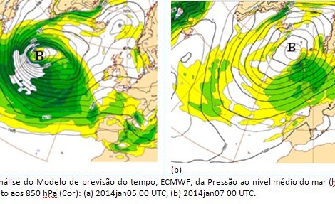
The depression centered on the east coast of the USA on day 3 at 00 UTC, with about 1000 hPa, crossed the Atlantic during days 4 to 6, and underwent a process of explosive cyclogenesis recording a minimum pressure value of 936 hPa at 00UTC of January 5th (Figure 2a).
At 00UTC on 7 January it was located northwest of Scotland, with about 965 hPa, having been designated by Storm Christina by the University of Berlin (Figure 2b).
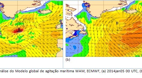
This depression caused very high swell values in the North Atlantic, with a significant wave height exceeding 14 meters northwest of the Azores on day 5, propagating to the east, originating, on day 6, waves of significant height of around 9 meters on the west coast of the Mainland (Figure 3).
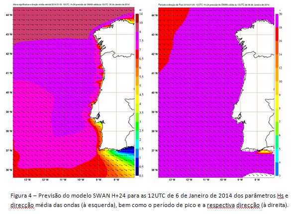
The forecasts of maritime agitation on the Portuguese coast of the numerical models of limited area used in the IPMA, European Shelf Model (LAM) of the ECMWF and the Simulating Waves Nearshore (SWAN) predicted a sea wave characterized by a long period swell (peak period) above 18 seconds) and with significant height (Hs - ie, the mean value of the highest third (1/3) of the waves) greater than 7 m north of Cabo da Roca and up to 6.5 m between Cabo da Roca and Sagres, to 12UTC on 6 January, with a predominant WNW direction (Figure 4).
Also according to the numerical models, the region south of Cabo da Roca would have its most critical time interval (with Hs greater than 7 m) in the late afternoon of the 6th.
In this sense, « following the monitoring, surveillance and forecasting of the sea state conditions and in accordance with the criteria for issuing meteorological warnings of maritime agitation, the IPMA issued on January 5th a red warning – corresponding to waves with heights (Hs) greater than 7 m – which was in force between 09 UTC on the 6th and 00UTC on the 7th (later extended to 06UTC) for the entire west coast of mainland Portugal».
 The predicted values of the sea wave by the numerical models, as well as the predictions of the Operational Weather Forecasting Center of the IPMA were corroborated by in situ observations obtained with ondograph buoys from the Hydrographic Institute (http://www.hidrografico.pt/boias-ondografo.php) and by remote observations obtained with altimeter radar aboard the Jason-2 polar orbit satellite.
On the Leixões buoy, waves with Hs up to 9m and maximum height (Hmax) of 13,5 m and Sines buoy waves with Hs up to 9 m and Hmax up to 15 m, between 14 and 20 UTC.
Additionally, waves with an average period of about 12 and 15 seconds were recorded for Leixões and Sines, respectively, with maximum periods of more than 20 seconds being reached in both buoys.
IPMA explains that "the energy of the waves associated with their breaking is determined by the values of the height and period of the waves, as well as the direction of the swell compared to the orientation of the coastline".
Thus, in the case of the Portuguese west coast, for the WNW waves that occurred, «the dissipation of energy by refraction (ie, by the effect of approaching the coast) was minimized and consequently led to a greater degree of destruction in the coastal areas».
In addition to all this, «the high tide of approximately 3.15 m will have occurred around 18:30 UTC (18:28 UTC for Cascais), coinciding with reports of flooding and destruction of bathing structures in different areas of the Portuguese coast, since the high tide allows the break to occur closer to the coastline».
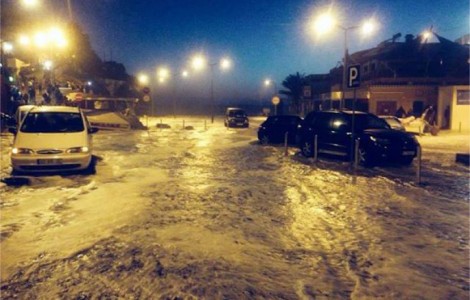
As a result of all these more or less extraordinary conditions, across the western Portuguese coast and even in much of the southern coast of the Algarve there were losses that were difficult to account for in structures and equipment by the sea.


Comments