The past month of August was considered, in mainland Portugal, as very hot and very dry, having been the 3rd hottest August ever in Europe, announced the Portuguese Institute of the Sea and the Atmosphere (IPMA) in its Climatological Bulletin.
Thus, in Europe, along with 2017 and 2021, August was the hottest month ever. The average global temperature in August was 0.3°C higher than the average value for 1991-2020. There was an anomaly of + 1.71°C in relation to that average value.
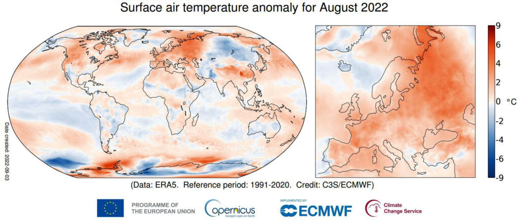
August temperatures were higher than the 1991-2020 average across most of Europe (Figure 1). Warmer-than-average conditions were seen at the eastern end of the continent, in a band stretching from the Barents and Kara Seas to the Caucasus.
Temperatures were also generally high in the western part of the continent, but not as extreme as in early summer and when compared to August 2003 and 2021.
In terms of rainfall in Europe, last month this was well below average, as were soil and relative humidity in much of western and eastern Europe: drier-than-average conditions range from the Iberian Peninsula to virtually the entire continent, including the UK, Ireland, southern Scandinavia as far as Russia and as far as the Black Sea and Caucasus.
The extreme and prolonged conditions of heat and drought affected the water level in rivers, agriculture and transport and facilitated the spread and intensification of wildfires.
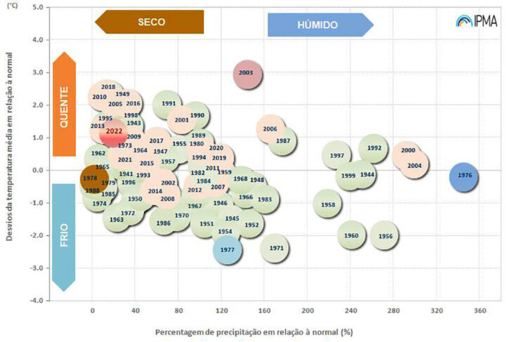
In mainland Portugal, the month of August was classified as very hot in terms of air temperature and very dry in terms of precipitation (graph above).
The mean value of the mean air temperature, 23.30°C, was 1.15°C higher than the normal value.
The mean maximum air temperature, 30.50°C, was also higher than normal with an anomaly of +1.79°C, while the mean value of the minimum air temperature, 16.10°C, was 0.60°C above normal.
During the month of August, the air temperature values were almost always above the monthly average value, except in the periods from 14 to 17 and 29 to 31. The hottest periods occurred on days 1 and 2 and from 19 to 23; on these days there were deviations in the maximum temperature of more than 4°C and of the minimum temperature of more than 2.0°C.
The IPMA also recalls that there were two heat waves in August: the first in the period from 29 July to 14 August in 11 mainland stations, especially in the North and Central interior, lasting between 6 and 16 days; the second took place between August 20 and 29, in the Northeast region (4 seasons) lasting between 7 and 9 days.
In terms of precipitation, the month of August was the 4th driest since 2000. The total precipitation in this month, 2.7mm, corresponds to only about 20% of the normal value.
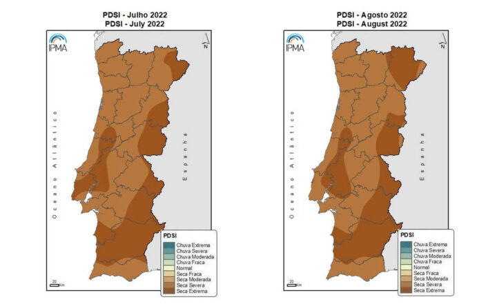
According to the PDSI index, on August 31, the meteorological drought situation continues throughout the territory, with severe and extreme drought classes prevailing throughout the territory: 60.4% in severe drought and 39.6% in extreme drought.


Comments